High Water Marks, life jackets, and other “innovations” as California leads in flood preparedness

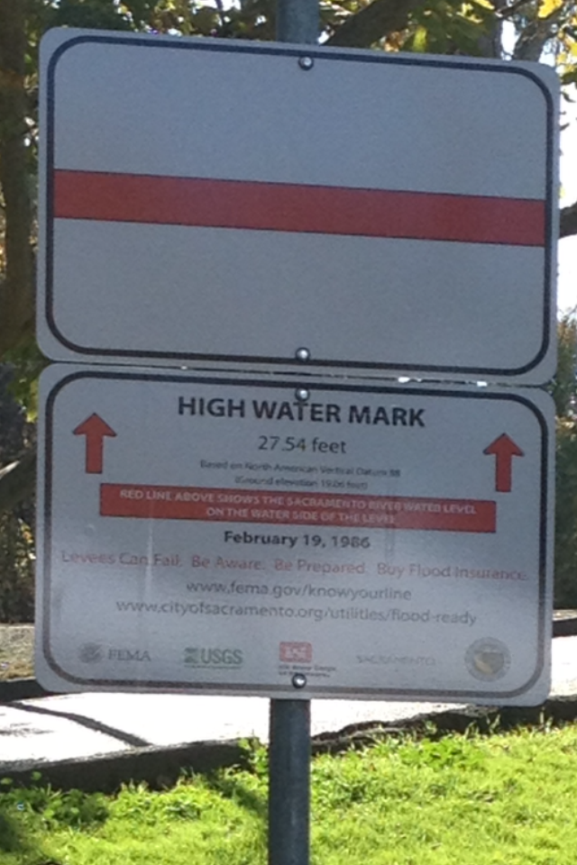
Last Friday was a day of great for progress in the communication of residual flood risk in California as the High Water Mark from the February 19, 1986 flood was unveiled in Garcia Bend Park  in “the Pocket” area of Sacramento. The Pocket is a neighborhood in a deep floodplain protected by levees. The signs are part of the “Know Your Line” national initiative—a multi-agency effort, led by FEMA to post high water marks from past floods around the country and increase community awareness of flood risk.  California is one of 6 or so pilot communities across the US and a total of 9 or 10 markers have been posted in both Sacramento and Roseville.

High Water Mark from 1986 Flood, posted in Garcia Bend, Sacramento, California (the Pocket)

High Water Mark from 1986 Flood, posted in Garcia Bend, Sacramento, California (the Pocket)

The high water marker above reads, “Levees Can Fail: Be Aware. Be Prepared. Buy Flood Insurance.

We will always face the threat of flooding in Sacramento,” said Tamboor Ellen with the Sacramento District Corps of Engineers. Standing in front of a levee, her words were bold, honest, and very fitting with both the legislatures’ passage of the Central Valley Flood Protection Act in 2008 which requires flood risk notification in levee-protected areas, and with California’s Flood Preparedness Week, November 4-8, 2013.

While risk communication in all flood prone areas is critical, the High Water Mark in the Pocket area, is especially important because it acknowledges the risk of flooding in an area protected by a levee— areas where often a false sense of security develops. As previous studies have mentioned, the NFIP also requires no building restrictions, no flood insurance, or flood hazard disclosure on lands protected by levees—so long as the levees are accredited by FEMA.
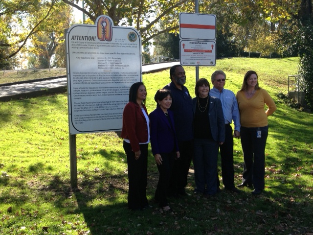
Congresswoman Matsui poses under the new HWM, with staff from DWR, FEMA, the Corps, and the Cities of Roseville and Sacramento

Congresswoman Matsui poses under the new HWM, with staff from DWR, FEMA, the Corps, and the Cities of Roseville and Sacramento

The agencies behind California’s effort included: FEMA, the USGS, the US Army Corps of Engineers, the California Department of Water Resources (DWR), the City of Sacramento, and the City of Roseville.

Notably not present is the  flood-prone neighbor, the City of West Sacramento. The lack of participation may be because they recently assessed themselves to upgrade the levees that protect West Sacramento (in order to further develop it), and the City may find it therefore politically unacceptable to participate in a risk communication effort.  If this is the case, it is an unfortunate situation, yet not a unique predicament in this country. Many communities in levee-protected areas have incentive to keep flood risk quiet to maintain business interest and not “alarm” the public. I was once told by a local  district engineer, “Yea, but if we tell [the public] that they can still flood, despite the levee, they then start yelling at us and saying we’re not doing our job [protecting the levee].”

Political pressure, and fear of depressed home prices or lack of economic investments cause local officials to keep flood risk quiet.

Political pressure, and fear of depressed home prices or lack of economic investments cause local officials to keep flood risk quiet.

John Barry captures how this has been a particular struggle for cities even as early as the 1920s in his excellent book,  Rising Tide: the Great Mississippi Flood of 1927 and How it Changed America 

‘If New Orleans is ever flooded, the world will not know it unless there is some outside newspaper man there.  The newspapers of New Orleans have not told their people the actual situation. It’s business depression that’s feared. Many leaders of the town had much rather take a chance at loss of life and destruction of property than face the possibility of the grain markets slumping a couple of notches…”

Given the difficulty in communicating flood risk to the public, and the challenges that cities must face in wanting to maintain an attractive place to build and live, while ensuring their residents are as prepared as possible–I think we should applaud those communities that do take it on, and find out how to help others do the same. To learn about how other examples or about how your community can participate, please go to this link or contact me and I’ll put you in touch.

The rollout received a good crowd with some participation of the general public—though it seemed a majority of participants were members of the agencies themselves. The agencies staffed the booths to answer questions from the general public and pour water over a clever model to show how rivers cause damages to property.  All partners gave a speech including Congresswoman Doris Matsui, a champion of structural flood protection for the Sacramento area. Many speakers acknowledged the ease with which we forget the flood when we haven’t seen one in years.

Bill Edgar, President of the Central Valley Flood Protection Board, joked about how many flood control officials working for DWR (and the Corps of Engineers) live in the Pocket area (designated a “rescue” zone on the flood maps because it could flood very deeply and very rapidly without sufficient time for evacuation), —he said they all understand the risk and it gives them a vested interest in keeping it dry. You might wonder the same about the number of DWR employees living in Natomas.
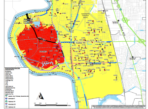
The area in red is designated a "rescue zone" and yellow is an evacuation zone. Sacramento River is in blue on the left. Source: CIty of Sacramento  http://www.cityofsacramento.org/utilities/flood/Map_17b.pdf

The area in red is designated a “rescue zone” and yellow is an evacuation zone. Sacramento River is in blue on the left. Source: CIty of Sacramento http://www.cityofsacramento.org/utilities/flood/Map_17b.pdf

Keith Swanson of DWR grew up in the area and he said that what he remembers of the river was that “children were on one side of the levee—water was on the other side.” He recalled that before the 1986 flood, his family kept life jackets by the door.

Further thoughts?  Great event and many Kudos to the efforts at the USACE Sacramento District (namely Judy Soutiere) and DWR Flood Risk Communications team who were the driving forces behind this and other flood risk preparedness events throughout the region. I am also regularly inspired by the increasing number of state and federal officials who express that risk communication is high on their priority list. I hope high water marks get posted more frequently—and better yet, in residential neighborhoods–not just parks and fire stations– so that would-be homebuyers can get a sense of where they are buying a home and so that people in the neighborhood get daily reminders. This may not guarantee a different home-buying decision, but at least it will get more people in the community thinking about it.

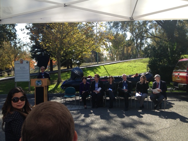
Let’s all appreciate for a moment how the podium and speakers were positioned in front of an inflatable boat.

City Councilman and the other speakers sitting in front of inflatable rescue boat.

City Councilman and the other speakers sitting in front of inflatable rescue boat.

Maybe the high water mark sign should read: Levees will fail. Be prepared, buy a boat.

Posted in Flood Risk Management, Flood Risk Perception, Uncategorized | Tagged , , , , , , , , | Leave a comment

Multiple Layers of Safety in the Netherlands and United States

Back on U.S. soil for nearly a year, I’ve linked up with another Dutch research institute to launch an initiative aimed at  comparing our two countries on one particular matter: implementing multiple layers of safety for improved flood risk management.

Background

A comprehensive flood risk reduction plan would in theory reduce the frequency of floods, and it would also minimize the consequences once a flood occurs.

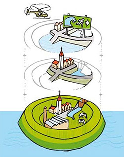
To do so requires implementing “Multiple Layers of Safety”  (the Lake Ponchartrain Basin Foundation has championed the similar “Multiple Lines of Defense”):

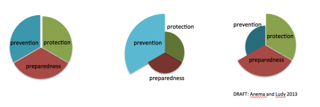
Dutch Concept of Multi-Layered Safety: (I) Prevention, (II) Protection, (III)

Dutch Concept of Multi-Layered Safety: (I) Prevention, (II) Protection, (III)

Layer 1:       Prevention

(addresses probability of flood through structural measures like dikes, levees, dams, storm surge barriers, bypasses, levee setbacks, etc).

Layer 2:      Protection

(addresses consequences of flood by insurance, limiting exposure through buyouts, zoning regulations, building codes and flood proofing, in-place protections, subway tunnel closures, etc)


Layer 3:      Preparedness

(addresses consequences of flood through evacuation, emergency response, and recovery).


Any flood risk reduction plan would require some level of investment in all three safety layers.

A flood risk management plan would require investment in managing both probability (prevention), and consequences  of flooding (protection, and preparation)

A flood risk management plan would require investment in managing both probability (prevention), and consequences of flooding (protection, and preparation)

Our research question: in a given flood-prone region in the United States and the Netherlands, what determines the relative level of investment in prevention, protection, and preparedness, and why?

  • From a purely risk-based perspective how would the relative size of each piece change with increasing/decreasing probabilities and consequences?
  •  What other factors at play would increase or decrease the relative size of each?
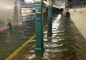
Flooded subway from Hurricane Sandy. source: inhabitat.com

Flooded subway from Hurricane Sandy. source: inhabitat.com

For example, how, where, and why will we rebuild the greater New York region? Will we build a storm surge barrier and go back to business as usual? Will we protect barrier islands? Elevate? Buy out? All of the above?

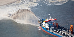
Dune nourishment for coastal protection. Source: Dutchwatersector.com

Dune nourishment for coastal protection. Source: Dutchwatersector.com

Why will the Netherlands indefinitely dredge the North Sea to nourish the coastal dunes no matter how costly it becomes?  Why don’t they have evacuations plans yet, and why do many Dutch engineers tend to scoff at communicating risk?

Why did Valmeyer relocate after the 1993 Mississippi Floods instead of build a levee or elevate houses?

Why after the risk-informed “Green Dot Map” leaked to the New Orleans public did many neighborhoods rebuild in place?

None of my questions above express a preference or an opinion. They’re just questions. Likely the answers are obvious to some you. The decisions behind the aforementioned examples may have been risk-based, though likely there were  also social, cultural, economic, or political factors at play, and those are what we want to elicit from the research effort.

Are there notable trends and preferences in the United States that are different from those in the Netherlands?  In the US, the National Flood Insurance Program has been identified as responsible for increasing risk.  In the Netherlands, there is no insurance program because none can afford to take on the risk (so the government does).

Subtle (or not so) differences in history, culture, political, and insurance systems have set the context for the two countries’ current state of flood risk.  The Netherlands may be arguably safer than the United States from a probability standpoint with 10,000-year protection on the Coast.  The United States may be arguably safer than the Netherlands from a consequences standpoint with experienced flood fighters and elevated houses.

Going forward, the goal of this study is to understand the rationale behind investing in  certain flood risk reduction measures and safety layers over others in attempt to identify barriers and opportunities to implementing multi-layered safety approaches in both countries.

There will likely be a survey and interviews later on to professionals in the field—ideally gathering opinions from people in all three sectors. Further, we will use case studies to illustrate themes highlighted in surveys and interviews.

We have some case studies selected already, but if you were involved in a particularly interesting (or boring) case, or want to participate in the study somehow, please comment on it here or send me a message with some of your thoughts.  For questions/comments on our proposed method, please send email.

Yesterday I was asked what commercial company is sponsoring this study and that answer is: none. This effort is funded through Unesco-IHE, and was developed by myself and my research partner after my year as a Fulbright fellow. We are very interested in applications of this topic in both countries.

Jessica (dot) ludy (at) gmail (dot) com.

Posted in Uncategorized | Tagged , , , , , , | 1 Comment

Can the Dutch teach us something on the power of communication?

My time here has been focused on learning what we can take away from the Dutch in terms of water management expertise. What is it, you ask?   I know the suspense must be killing you, so I’ll give away part of my discovery:

The Dutch find incredibly creative and simple ways to communicate important messages to the masses. They put a lot of time and effort into public outreach and communication, which  from my observation over the past 8 months, has had a very powerful effect on increasing understanding and building support for government (and other) actions.

What could it mean for the United States?

In general the Netherlands is not quite such a litigious society as the United States, so they spend less time in the court room.  But they do, as a culture, strive for something called “overeenstemming”, or as we call it, consensus.  This takes its time as well.   I often wonder in the United States,  whether our advocates, project developers, governments, scientists, and engineers could put more time and efforts into public outreach, (see great examples below), especially with controversial topics, perhaps we would find ourselves in more agreement and less at a standoff–  At least we might have less anxiety over the unknowns, (be more open-minded as a result), and we could have a more-focused awareness and discussion on what it would really mean to:

  • expand a bypass
  • designate an emergency overflow area
  • restore a floodplain
  •  reinforce levees in place
  • update building codes behind dikes
  •  re-operate dams, or
  • (gasp) even demonstrate conveyance options in/around/under/through/upside-down/inside-out of the California Bay-Delta.

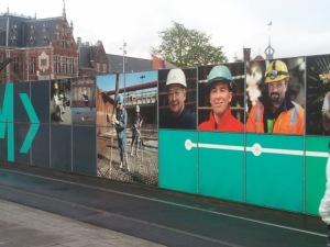
In the Netherlands, it is not uncommon to find large nice posters plastered all over public works projects to explain to the public why it is their train station is under construction yet again.  I rarely hear people cursing the delays (or at least significantly less than in the United States) as a result of it because they understand what the long-term goal is. You also commonly see billboards depicting the future of Amsterdam’s harbor (and how the people will be a part of it!).

One of many posters outside Amsterdam Central Station

These signs at Delft Station takes you to the website where you can learn about the new train station modifications in Delft.

Educational Videos:

I just came across the following and feel compelled to share:  At one minute-long each,  hydrologists, engineers,  and animators provide even children a “Primary school” understanding on the “Room for the River” program.   These animations explain the (rather) complicated hydraulic processes of giving room to river with the story of the Sheep Sieb (Schaap Sieb). Other links on the site also show how the Dutch are trying to involve young adults in water management early on.  I think these approaches are useful beyond targeting young people, however. Such concepts for a video, unmuddeled by opinion or technical jargon, can really help explain to stakeholders (including educated decision-makers) what we all mean when we’re talking about such things.

I’ve embedded a few of these (what I believe to be) fantastic videos here. You do not need to know Dutch to appreciate them. But feel free to check out the site for the complete set.

Key words : “dijk”= dike/levee  “overstroming”= flood.  “Hoogwater”= high water.

Enjoy!

Dike Strengthening:

Levee/Dike Setbacks

Flood Bypass

Lowering the groins

For more, check out the Room for the River website

Posted in Uncategorized | Tagged , , | 3 Comments

Lowdown on the high water…and room for rivers explained

So high the water was risin’ our men sinkin’ down
Man, the water was risin’ at places all around,
boy, they’s all around
It was fifty men and children come to sink and drown

—High Water Everywhere (Part 2), Charlie Patton

A great many blues musicians sang about high water and an old professor of mine once told me there are three things you can do with it:

1- store it    2-convey it to the sea     3- let it flood

Olifants River in Flood. Source: Flickr. Author “Albrigi”

Simple enough.  For years, we’ve mostly managed high waters through options 1 and 2, ignoring 3, with concrete and earthen dams and levees to keep the water away. Championed by engineers like Humphreys on the Mississippi in the mid 1850s, advanced engineering and technologies have “tamed the river,” reducing the frequency of smaller floods (as well as our memories of them) and allowed for more economically productive uses of floodplains. As a result, communities have thrived for centuries on low-lands thanks to deepened channels which allowed for navigation and trade, flat fertile soil for agriculture, residential and commercial development, and beautiful waterways as a scenic place to recreate.

FISK Map 1944, Historical Courses of the Mississippi River.

Over time, this way of management restricted the ability of a river to maintain it’s preference–option 3 above: to spread out on to a floodplain every once in a while when waters are greater than the channel capacity.

The Delta Blues remind us that such is the desired course of rivers where floodwaters use the floodplain– irrespective of  human settlement on it.  Consider  also the numerous historical courses of the Mississippi River.

Mark Twain also understood this well.

“The Mississippi River will always have its own way; no engineering skill can persuade it to do otherwise…”

As did William Hammond Hall,

“It should be fully understood then, that floods will occasionally come which must be allowed to spread.”

Giving room in the past

Humans know that we have repurposed floodplains and placed valuable assets in a rivers’ path.  We are no stranger to the fact that rivers need room in order to protect our cities, farms, industry, and way of life. We remember the Great Floods of 1927 and the multiple breaches on the Missouri and Mississippi systems during 2011.

1927 Mississippi Flood, Hamburg Louisiana. Source: American Environmental Photographs Collection, Department of Special Collections, University of Chicago Library/File

As early as 1918 in the Sacramento Valley,  and in 1928 on the Mississippi River (after 700,000 were displaced), Americans sought to make space for the river. Evacuating of 250,000 Netherlanders in the Rhine basin in 1995 inspired the Dutch to create a national program to let water back into a landscape they had spent centuries keeping dry. Most recently in the San Joaquin Valley after 1997, farmers, engineers, hydrologists, and politicians acknowledged that traditional storage and conveyance alternatives were not alone enough and started discussing a plan. (See: Yolo Bypass, Mississippi River & Trib, Room for the River, and Lower San Joaquin Bypass referenced in 1998 Preface to Kelley’s Battling the Inland Sea.)

Giving room today

Making room for rivers was just the subject of a recent Scientific American article, as well as one in the Economist. Expanding floodways made a grand entrance to the first draft of California’s Central Valley Flood Protection Plan (table 3-2) as a viable way to meet multiple objective, and  to a lesser extent, “Room for Rivers” is also considered in the 5th draft of the Delta Plan. Lastly, in 2008, California Legislation from SB 5 (California Water Code Sec 9163 (c) ) required the state consider the feasibility of a bypass on the Lower San Joaquin.

While the concept and buzz word of “Room for Rivers” might be understood by some, what follows is a brief explanation for those who aren’t quite so hydraulically inclined (great blog by the way), and some detail for those who want to know the practicalities.

  1. What does “room for rivers” mean?
  2. How do you give a river room? (and where is it appropriate to do so?)
  3. What are the benefits? 
  4. Example Projects 
  5. Challenges?
  6. Areas of further research

The explanations and project examples below demonstrate that giving room to rivers actually incorporates all three options above–storing high water, conveying high water, and allowing high water to overflow the banks from time to time.

Presented factually, this post does not advocate for or argue against certain projects– the attempt is to provide information and opportunity for a discussion. There are some additional resources provided at the bottom and please comment if you have questions.

  Continue reading

Posted in Ecosystem Function, Flood Risk Management, Uncategorized | Tagged , , , , | 2 Comments